Birregurra Flood and Drainage Strategy – community information sessions
Colac Otway Shire Council is inviting the Birregurra community to share their stories and local knowledge of historical flood events as part of the Birregurra Flood and Drainage Strategy project.
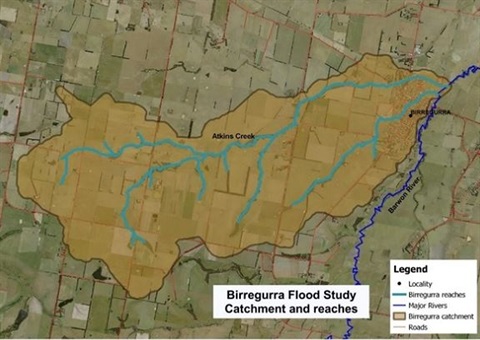
Council, in partnership with Corangamite Catchment Management Authority, Victoria SES and DELWP is undertaking the project to determine a detailed flood analysis and identify areas in and around Birregurra which are impacted by flooding.
Council’s Manager of Assets and Project Delivery Jeremy Rudd said the project aimed to create a more up to date flood mapping of the Birregurra area.
“Our current knowledge of flood levels and mapping are outdated and require review to avoid placing people and property at risk from flood events.
“This is an important local project which will assist with emergency management when it floods and also facilitate improved land use planning and development decisions for properties which may be impacted by flooding.
“The project will also investigate opportunities to reduce the impact of future flooding.”
Mr Rudd said Council were seeking local knowledge and community input toward the project.
“Council would like to hear from the Birregurra locals on their experience with flooding in the area; if you have any old photos or references to historical markers of floods which have occurred we’re really interested in receiving that information.
“Our focus will be on the water catchments of two creeks which feed into the Barwon River, Atkins Creek and another unnamed waterway which runs through the middle of Birregurra,” Mr Rudd said.
Council staff invite community members to the following consultation sessions:
- Out the front of the Birregurra General Store on Saturday 7 December from 9am to 12pm;
- Birregurra Market on Sunday 8 December from 9am to 1.30pm; and
- Outside the Historical Society (45 Main Street) from 2pm to 3pm.
Anyone seeking more information on the project is encouraged visit Council’s website


