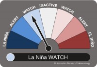
The Bureau of Meteorology has raised its (ENSO) Outlook status to La Nina WATCH.
While a La Nina is not a certainty, this means there is now around a 50% chance of one forming in 2020. This is double the normal likelihood of a La Nina occurring in any year.
Bureau manager of long-range forecasting Dr Andrew Watkins said changes in the surface temperature of the tropical Pacific Ocean indicated a rise in the chance of a La Nina event this year.
“Tropical Pacific Ocean surface temperatures have cooled in recent weeks, and models suggest this cooling will continue through winter and into spring,” Dr Watkins said.
“Temperatures in the top 150 metres of the tropical Pacific are also cooler than average. This means that the surface cooling is not likely to disappear quickly.”
But Dr Watkins noted that a cooler Pacific Ocean is only part of the La Nina equation.
“This cooler ocean joining forces with the atmosphere is the cause of changes in global weather patterns.”
“Other , such as stronger trade winds and lower air pressure over Australia compared with the central Pacific, have yet to appear. Once we start to see a change in these weather patterns, the likelihood of a La Nina event will increase much more. And it also increases the chance of a wetter second half of the year for Australia.”
A La Nina event typically brings above-average winter-spring rainfall for Australia, particularly across eastern, central and northern regions.
It also brings cooler days, more tropical cyclones, more snow and an earlier onset of the first rains of the wet season across the north.
The last La Nina to have a significant impact upon Australia lasted from 2010-12.
The initial phase of the event in 2010-11 was one of the strongest La Nina periods on record. As a result, the saw Australia’s wettest two-year period, with widespread flooding in many parts. The year 2011 was Australia’s coolest on record in a decade (2001-11).


