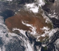
The Bureau of Meteorology is warning of the potential for severe weather throughout significant areas of eastern Australia in the coming days as two weather systems bring rain and thunderstorms across a large area.
Tropical Cyclone Owen is currently moving slowly westward in the Gulf of Carpentaria as a category-one system, and the current forecast indicates an intensifying trend to category-two later today, and category-three by tomorrow morning.
Manager of the Bureau of Meteorology, Extreme Weather Desk, James Taylor, said Owen is then expected to move toward the east during Friday and into the weekend, bringing large rainfall totals and strong winds to northern Queensland.
“Heavy rainfall potential exists for much of coastal Queensland during the weekend, with Tropical Cyclone Owen forecast to move southward,” Mr Taylor said.
“Meanwhile a low-pressure system is forecast to develop over Victoria during Thursday. The low looks likely to gradually move to southwestern NSW on Friday then southwards during the weekend to be south of Tasmania by Sunday night.
“This system has the potential to draw moisture southward from Tropical Cyclone Owen, creating a large cloudband with associated severe thunderstorms along much of the east of the continent,” he said.
“Heavy rainfall associated with the cloudband looks likely to affect Victoria on Thursday then contract southwards during Friday. Southeastern South Australia and northern and eastern Tasmania may also be affected by heavy rainfall over the next few days.”
Severe thunderstorms within the cloud band are predicted for eastern New South Wales, however associated heavy rainfall is likely to be sporadic in nature.


