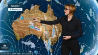
METEOROLOGIST, GRACE LEGGE: Hello from the Bureau, here with an update on the potentially severe thunderstorms and springtime cold snap expected through eastern Australia.
A large cloud band has formed through central and eastern Australia, bringing showers and thunderstorms. The band is due to the interaction of a humid, tropical airmass being dragged south ahead of a trough—with colder conditions behind it, leading to this unstable weather.
Thunderstorms are likely to develop along the trough and within this band today. The risk of severe thunderstorms extends all the way from the interior of WA, through southern NT, into Queensland and central parts of New South Wales and Victoria. There is a risk of damaging wind gusts, large hail and possibly heavy rainfall with these thunderstorms.
The area of storms will then push further north with the trough on Wednesday, clearing Victoria and moving through New South Wales, Queensland and the NT. While the storms are likely to continue on Wednesday, our focus also turns to this deepening low, which may bring damaging winds to some parts of southern SA along with a cold outbreak. Temperatures are likely to drop 5–10°C below average for this time of year and we may see small hail and heavy showers develop.
On Thursday the cold air and gusty conditions extend further east, with southeastern Australia likely to see temperatures significantly below average and even possible snowfalls above 1000m for Victoria.
Through New South Wales, northwesterly winds could result in a dust storm through the west and may even impact Canberra and Sydney.
From Thursday and into Friday we see a low forming just east of Tasmania, and we could experience gusty winds and significant rainfall through parts of Victoria and Tasmania. This is highly dependent on the position of this low and it is hard to predict the exact area of these impacts this far out.
So keep up to date with the weather on the Bureau’s website and app, and stay tuned to warnings and forecasts as they’re updated.


